


Menu

 Siyeon Oh ㅣ
 Approval 2026-05-13 |
 No.23 ㅣ view : 194


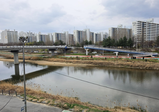
A photo of Jungnangcheon and Hancheon Bridge
For students looking to stay active, SeoulTech’s surrounding areas have plenty to offer, with streams, parks, and mountains all within easy reach. In this article, The SeoulTech highlights the best spots to visit.
Jungnangcheon and Danghyeoncheon
Jungnangcheon is a first-order tributary of the Hangang and the longest river in Seoul. Danghyeoncheon is a 3.5 km-long local stream that originates from Suraksan in Nowon-gu and flows into Jungnangcheon. Together, these streams form a continuous and scenic path well-suited for outdoor exercise.
The Jungnangcheon walking path is popular for running and cycling, with a road way on the side and a stream on the other. Hancheon Bridge crosses Jungnangcheon along this route. The path is lined with trees and grass, providing a healthy and refreshing environment for jogging, walking, or cycling. The trail also separates bicycle lanes and walking paths, making it safer for running, walking, inline skating, or riding bicycles and scooters. Additionally, there are facilities, such as a basketball court, inline skating rink, outdoor exercise equipment, allowing visitors to enjoy a variety of outdoor activities.
Along Jungnangcheon, Jungnang Rose Park provides a beautiful space for both exercise and relaxation. The park features a theme garden and several photo zones, making it a popular spot for walks with friends or family. It also hosts the Jungnang Rose Festival every May, and a large library on the grounds allows visitors to rest and read, making the park a perfect place to combine activity and leisure.
At the meeting point of Jungnangcheon and Danghyeoncheon, Nowon-gu opened Nowon Dumulmaru on January 23, 2025. This is a space dedicated to healing and relaxation for local residents and visitors. The name “Dumulmaru” was inspired by Yangpyeong’s famous Dumulmeori, a place where two bodies of water meet. The space reflects the convergence of the two streams and provides a scenic area to rest after exercise. Visitors can enjoy coffee or ramen at the café while taking in views of the streams.
Buramsan and Suraksan
Buramsan and Suraksan are mountains located in Sanggye-dong, Nowon-gu, with Buramsan lying to the south of Suraksan. The hiking trail connecting Buramsan and Suraksan is popular among hikers, and is about 11 km long. At the entrances to Buramsan and Suraksan, there are map boards to guide visitors. Near the top of Buramsan, there is a Buram-jeong, a traditional octagonal pavilion where people usually rest. If you reach the top around 6 a.m., you may be able to take in the sunrise and enjoy a panoramic view of Sanggye-dong. Suraksan features Byeokun Valley and a waterfall, and the fresh air and natural surroundings help visitors stay active and reduce stress. Suraksan is also home to a sports town, which has a soccer field, a football pitch, and a baseball field, all of which need to be reserved before use.
Gyeongchun Line Forest Trail
The Gyeongchun Line Forest Trail is a railway park that was transformed from a former railway siteinto a green linear park. It is about 5 km long, and one of its main sections runs between Gwangwoon University Station and Hwarangdae Station. The trail passes Hwarangdae Railroad Park and Dokkaebi Market, and the nearby Gongneung-dong section is lined with cafés and pubs. The path near Hwarangdae Railroad Park runs alongside a former railway track where trains once operated, giving visitors a chance to take in the old trains displayed there. On the pedestrian bridge located near SeoulTech’s entrance, the bicycle lane and pedestrian path are separated.
These exercise spots near SeoulTech allow students to stay active and enjoy nature in their daily lives. The SeoulTech recommends them to students as places to relax during free periods and to recharge before or after classes.
Reporter
Siyeon Oh
cinamellow@seoultech.ac.kr


 Comment 0
 Posts containing profanity or personal attacks will be deleted
 HOME
HOME


 Korean Bingsu: A Sweet Tradition of Summer
 2026 Hwaetbul-Je
 COEX Exhibition: Media and Mechanical Engineering
 Inside SeoulTech’s Sunglim Global Kitchen
 2026 Major Fair: Helping Students Choose Their Major